Blog
It is not who is right, but what is right, that is of importance
June 02, 2021

Vertical, z-axis location
Sometimes referred to as the “missing component” in mobile location technology, z-axis is now a huge topic within the Emergency Number Network. So, does it solve the location inaccuracy other location methodologies do not? Does it provide a “dispatchable address?
Since mobile devices took over in the race against fixed telephony landlines, our Emergency Number Network has struggled to keep pace with the number of calls it now receives from a mobile device. Mobile emergency calls comprise over 70% of all ESN calls in most countries.
Location accuracy of those mobile calls has plagued the industry around the globe. GPS, cell tower triangulation and other location efforts have tried to figure out how to accurately locate a mobile caller who is on the move, and in rural, urban, and indoor environments. But still today, once that person steps inside a building (such as an apartment or office block), and moves off the ground floor, they effectively become impossible to trace. This doesn’t bode well if you need Responders to find you in your 12th floor apartment whilst you’re having a stroke and can’t communicate your address.
So can we resolve this “problem” with the “z-axis” location element? If we have estimated x, y, and now z coordinates, will this complete the “puzzle of location” …is the z-axis the final piece?
What is z-axis?
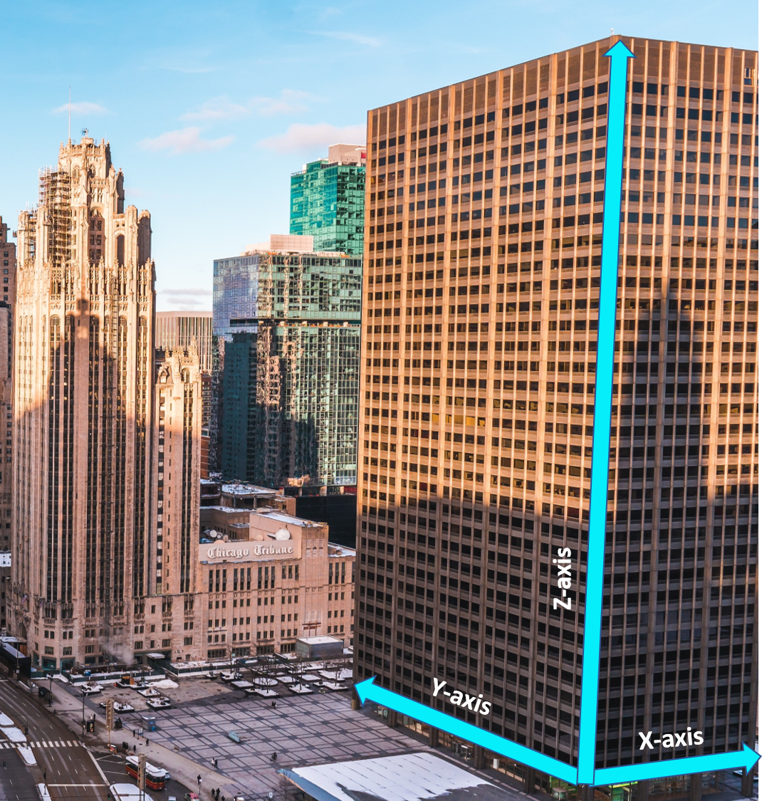 In short, the z-axis refers to the “vertical” location element. Mobile location methods today, if they’re used outdoors, do a pretty good job of finding you if you’re on a horizontal plane…on the ground. But when people move off that ground…when they walk upstairs, inside a building, those location methods fall flat.
Hence, the search for a “vertical” element to that location data began. Hoping that by providing one, it would allow Responders to narrow down their searches, saving time and saving lives.
How they find z-axis
E.g. in a downtown area with high rise buildings:
- Specific software is uploaded into smart devices that already have barometric reading capability.
- Barometric readings from the mobile devices are sent to a cloud-based network.
- At the same time, a physical network of “altitude base station” hardware is established outside in the urban environment and used to create a “picture of local environmental conditions”.
- This “local data” is also sent to the cloud-based network.
- The cloud-based network compares both the device and altitude station readings, working out a differential altitude reading.
- This final reading is then relayed back to the mobile device as a “final altitude” or Height Above Elevation.
Points to acknowledge:
1. The data is depicted as altitude: The floor level is an altitude reading, not a floor. So is this data “easily useable?”
2. Accuracy: The FCC state a z-axis needs to be +/- 3m, which is almost a 10ft difference “up or down”. This could cover a 3-floor area. Note that a standard floor-level height in an apartment building is approximately 2.5- 2.75 m, or 8- 9 ft. in height. Basements, parkades, lobbies are also different heights, and there is usually no 13th floor in hotels or apartment buildings. So now this gets more complicated.
3. Barometric (air) pressure is altered by:
- Temperature of air
- Altitude or Elevation
- Moisture
- Weather system changes
So sprinkler systems, fires, and HVAC inside commercial buildings can alter indoor barometric readings, irrespective of “base-station” data. This could lead to greater inaccuracies.
4. Altitude database. To assist in determining the altitude of a mobile wireless device, and “equate it” to a vertical location, it would be necessary to create an “altitude database” for ALL x-y coordinate locations which have more than one possible altitude. Why?
E.g. Two identical buildings, the emergency mobile caller is on the same floor, same time, same day:
- One building is on the coastline at sea level and has a barometric reading of 10219 Pa.
- Within the same city/regional municipality/district, but 15 km in land, the caller now has a barometric pressure of 10150 Pa.
Since barometric pressure is needed to determine altitude, even small increases/decreases in readings create a different result for caller vertical location:
https://www.mide.com/air-pressure-at-altitude-calculator
Using the calculator in the link, the altitude for both barometric pressures above, yield results separated by approx. 43 metres. Since an apartment floor is roughly 2.5- 2.75m high that is a huge discrepancy
Therefore having a measurement or two for a single city would not be enough. Even very close geographic locations would require accurate representation of daily barometric pressure readings, to ensure enough coverage.
This would require large amounts of data to be measured and collected (with huge infrastructure adaptations and equipment) plus storage of this information into a database, to allow for altitude determination by the wireless service provider.
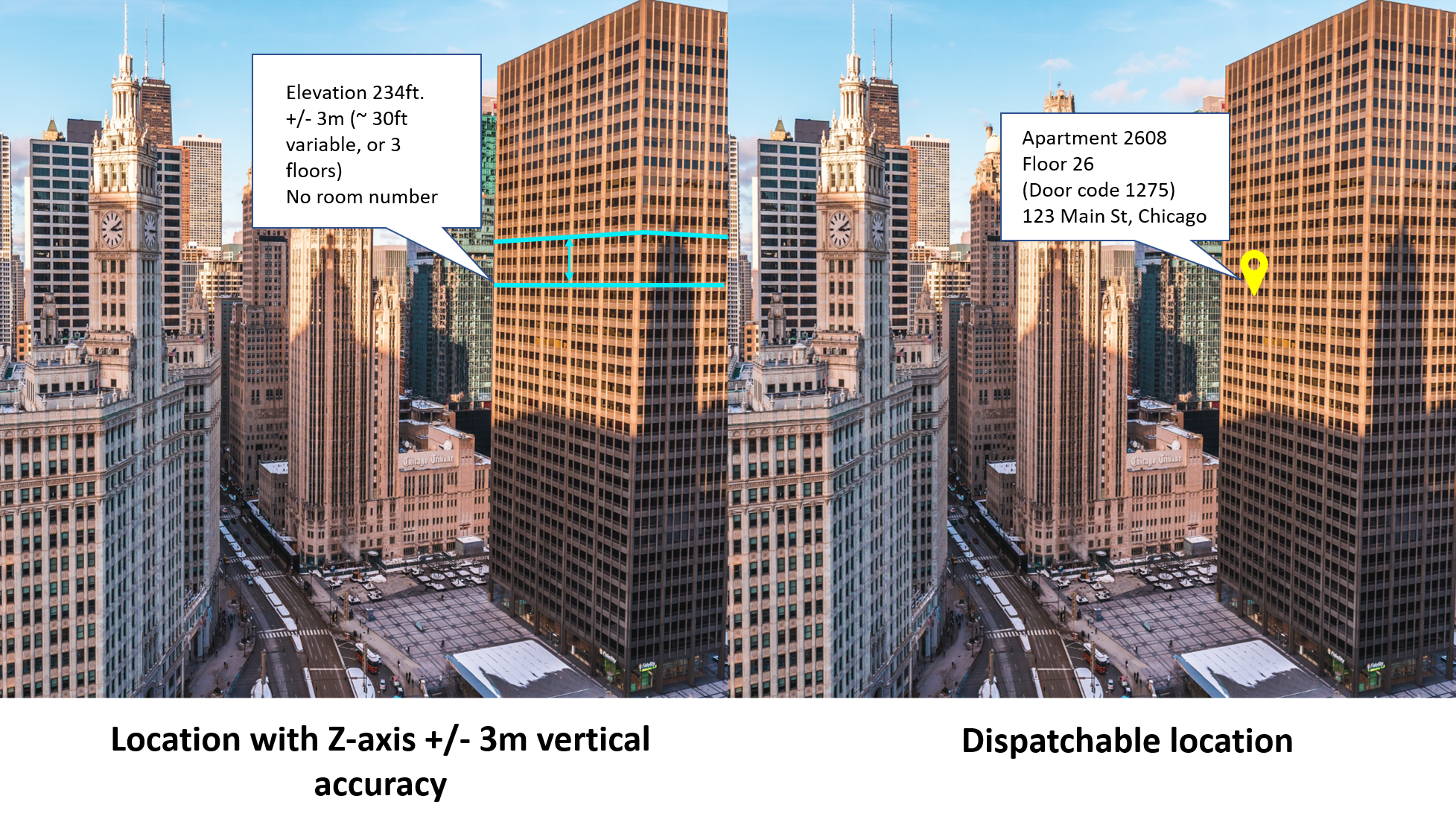
Z-axis and Dispatchable location
There is no doubt that having an extra layer of location data like z-axis assists Responders in locating emergency callers. And any improvement to 9-1-1, resulting in saved lives, is better than nothing.
But the level of detail around this technology appears to remain outside the requirement of dispatchable address, and there are also infrastructure/equipment costs and other discrepancies that should be weighed carefully.
To quote the FCC again, they state
“dispatchable location means a location delivered to the public safety answering point (PSAP) with a 9-1-1 call that consists of the validated street address of the calling party, plus additional information such as suite, apartment number .”
- GPS coordinates, represented as x -axis (latitude) and y-axis (longitude)
- Z-axis (altitude)
- County/State/Province, City/Town, and civic street address
- Indoor location with useable information such as floor, room, apartment number
There have also been some interesting articles published centred around what z-axis does and does not provide:
Last year International Association of Public-Safety Communications Officials (APCO International) replied to the FCC with a “Petition for Clarification” stating:
“[ The recently adopted z-axis rules could result in no meaningful improvements to 9-1-1 location accuracy. At the same time, the record reveals growing consensus that dispatchable location, floor level, and nationwide vertical requirements are feasible today. While the location accuracy rules need to de-couple dispatchable location from the NEAD, carriers should not delay efforts to leverage a variety of technologies to provide the most actionable information possible with 9-1-1 calls.]”
Read more information here:
https://ecfsapi.fcc.gov/file/1025866713987/APCO%20ex%20parte%20911%20location%20Oct2019%20final.pdf
Additionally, in an article covering new rules for Z-axis vertical location of wireless 911 callers:
“FCC commissioners yesterday voted to approve rules requiring wireless carriers to deliver 911 callers’ vertical location that is accurate within +/-3 meters in most cases, but critics expressed concern that the location information will not be provided in a manner that is useful to Public Safety. While the 911 vertical-location order was adopted, the vote was not unanimous . FCC Commissioner Jessica Rosenworcel dissented in part, noting that the height-above-ellipsoid (HAE) format that the carriers must use to deliver vertical-location information is not useful to Public Safety.
“There is not one 911 call center today that can take the raw numbers in height above ellipsoid and translate them into actionable dispatchable-location information ,” Rosenworcel said during a press conference following the FCC open meeting. “If we acted in this room today like the job is done, then we lied to you. And I’m afraid our decision was dishonest about whether the information is actionable.
“The fact so many 911 operators wrote into the agency and wrote to my office, telling me they were distressed that we would organize around information they could not use, I think is a testament to the fact that … we have a lot more work to do .”
So we can see that whilst z-axis is “part” of dispatchable location….it does not provide that “door to knock on” that Responders and Emergency Callers will benefit from most.
Henry Ford once said “Don't find fault. Find a remedy”.
And that is what we should do.